
Hornby Island Draft Bylaw No. 176 – pause request – revision request
Dear Trustees,
The map (Schedule D2) on page 5 of Draft Bylaw No. 176 is based on a 24 year old map. This old map has been updated by new more accurate maps issued by the Islands Trust Council in 2021.
Looking at the new maps (below) shows that the Draft Bylaw No. 176 is based on obsolete information. Unless the approval process is immediately paused and Draft Bylaw No. 176 is revised to reflect the actual state of Hornby Island groundwater, the Local Trust Committee will be unable to make informed decisions on the many important land, property, vacation rental, and secondary suite uses that are governed by Schedule D2.
Put simply, you cannot make the right decisions if you have the wrong information.
In particular, the new maps issued by the Islands Trust Council indicate that “Aquifer 1A”, as shown on the current Schedule D2, does not exist. The new maps are also much more precise and can be used to map Environmentally Sensitive Areas on a property-by-property basis. The map excerpts below illustrate this new accuracy, especially with regard to the Whaling Station Bay Peninsula (where Aquifer 1A is purported to be located).
It is my understanding that Islands Trust Council paid over $100,000 for this Ground Water Mapping Report. The Hornby Island Local Trust Committee should be provided with up-to-date and accurate Ground Water mapping information provided by the Island Trust Council before any further decisions are made. In the meantime, proposed Bylaw No. 176 should be placed on hold by the LTC on May 16, 2025 until the maps are corrected and updated.
Sincerely,
John Grayson, Hornby Island
Affiliations:
Winemaker/owner
Hornby Island Estate Winery & Farm
Treasurer
New Wave Wine Society – a province wide organization
Director
Hornby Island Farmlands Trust Society
Co-Chair
Hornby Island Economic Enhancement Corporation
Committee Member & Internet Lead
Hornby / Denman Islands Internet Committee
MAPS:
Below:
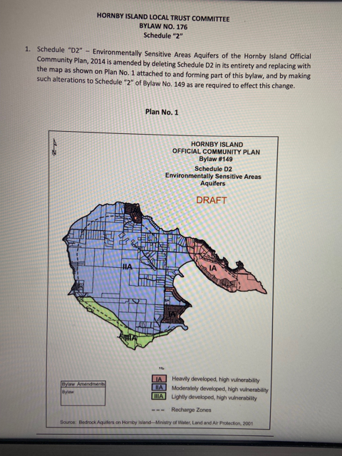
The pink portion on the right is Whaling Station Bay Peninsula.
The pink portion is marked “1A”
Below:
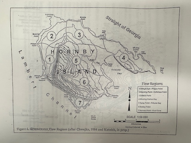
Historic Map from 1984 (41 years old) that influenced the creation of the map above.
Compare Whaling Station Bay Penninsula in each map – for all intent and purpose they are identical.
See the number “4” on the map below.
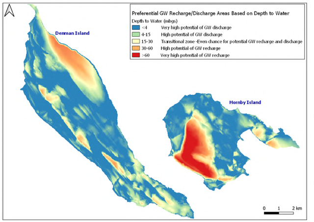
EXCERPTS FROM ISLANDS TRUST COUNCIL COMMISSIONED REPORT (2021)
APPENDIX 5: Potential Zones for Groundwater Recharge and Discharge based on
Depth to Water
Groundwater Recharge Potential Mapping for Study Islands
October 18, 2021
(Map)
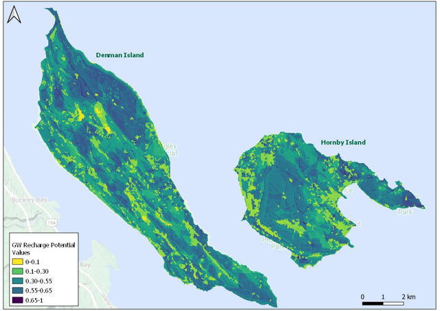
APPENDIX 10: Groundwater Recharge Potential Maps
Precipitation Interception Potential – See Below
NOTE TO READER:
THE COLOURS COVERING the majority of the Whaling Station Bay Penninsula area:
BLUE AREAS = High
PURPLE AREAS = Very High
The readings quoted (above) indicate that “Aquifer 1A”, as shown on the current Schedule D2 does not exist.
See the first map (Schedule D2) at the start of this section of maps for comparison.
JG
Groundwater Recharge Potential for Denman Island and Hornby Island
(Map)


